


P&K AST (TA Luft 2021 / AUSTAL)
Terrain Heights
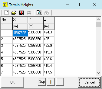
Form for the definition of terrain coordinates (area heights raster). In this form XYZ Triplets can be imported or exported. The area can be also shifted in this form (right mouse button / Alter Values).
The mesh size of the area heights raster does not have to match with the mesh size of the computation grid / computing area, however the computing area must lie completely within the area heights raster. The raster may not contain invalid values (NODATA_value) or gaps and must be regular for the computation.
No
Order Number, assignment will change when rows are inserted or tables are sorted.
X, Y and Z
X -, Y and Z-coordinate (in meters) of a area heights raster point. (X to the right (the east) ascending, Y upward (the north) ascending, Z height of the point)
Also see: