


P&K KFA (VDI 3781 part 4)
Background Image / Map
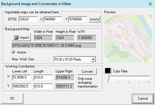
In this form, an image file can be defined as background. Files of the types gif, jpg, jpeg, tif, bmp, emf, wmf and png are usable, but preferably, a scalable format like emf or wmf should be used. The coordinates define the lower left and the expansion of the image. For files, which are accompanied by a coordinate reference file (world file, without rotation), these are read as well. The corresponding extensions are TGF, PGW, JGW or GFW.
Scaled PNG maps can be obtained via our Map Interface from www.openstreetmap.org. The necessary data for the scaling are contained in the file name, which therefore must not be changed.
Hint: Load image into a graphic program, rotate it, so it becomes horizontally aligned, then crop it to the above coordinates.
Supportet projections:
- EPSG:32631 = WGS 84 / UTM zone 31N
- EPSG:32632 = WGS 84 / UTM zone 32N
- EPSG:32633 = WGS 84 / UTM zone 33N
- EPSG:25831 = ETRS89 / UTM zone 31N
- EPSG:25832 = ETRS89 / UTM zone 32N
- EPSG:25833 = ETRS89 / UTM zone 33N
- EPSG:31467 = DHDN / 3-degree Gauss-Kruger zone 3
Coordinate System (optional): Complex coordinate transformations can be performed here. This feature may need to be installed separately.
Color Filter: With the slider one can make the image appear brighter and with the color button (when not black) a monochrome illustration can be obtained. This serves to unclutter other illustrations.
Max. Arbeitsgröße kann bei angeschalteten Expertenmode vergrößert werden. Damit wir die zu importierende Grafik, wenn größer, weniger verkleinert. Das erhöht die Qualität und vermindert die Performance vermindert.
Max. Work Size can be increased with Expert Mode enabled. Thereby the to be imported graphic will be less reduced in size (if greater). This will increase quality, but reduce perfomance.
Note: This form opens via click on  Import Map.