


P&K TAL2K (TA Luft 2002 / AUSTAL)
Graphical Tools for drawing objects
New Version P&K AST
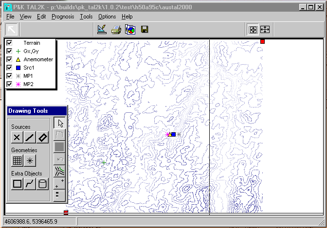
In this form various elements needed in the computation can be drawn or placed on a map. In the above example no map is shown, but height contour lines of the area.
 Background Image and Corner Points
First a map 1) should be loaded. To do so, the necessary parameters are to be set under ![]() Background Image .... The coordinates of the corners in this form do not need to be set, they can be defined by
Background Image .... The coordinates of the corners in this form do not need to be set, they can be defined by ![]() setting alignment points, or by moving the corner points (here red squares). With the corner points, the lower left and upper right corner of the map are defined. Moving the corner points alters their coordinates, not the coordinate system
setting alignment points, or by moving the corner points (here red squares). With the corner points, the lower left and upper right corner of the map are defined. Moving the corner points alters their coordinates, not the coordinate system
 Setting of the Coordinate System with Alignment Points
The user will be prompted for coordinates first (these are the target coordinates). Next, the user can place Alignment Points to the chart. After the second Alignment Point has been placed, the corners will be recalculated, which will result in the new coordinate system.
Legend Content
In the movable legend, elements can be toggled on and off. The names of the elements are usually the user defined names, or their standard descriptions. For computing grids, the name Grid followed by a number will be used.
 Legend
With this switch the legend can be switched on and off. If terrain heights are being used, a matching legend can be switched on as well.. In this case, elements which do not belong to the terrain heights are switched off.
 Undo
Undo
Here, beforehand made changes can be undone. Additional modifications have to be made in the forms under the menu Edit. Changes to Alignment Points cannot be undone.
Color
The color of the objects can be set, but will only be used for Extra-Objects and Sources.
Placement and alteration of objects
After the coordinate system has been defined, objects can be placed. Instructions for placement are shown in the status area at the bottom of the window. Further properties (e.g. of Sources) can be set under the menu Edit. If desired, objects can be deleted there. An object is set by selecting the type in the form Drawing Tools. In most cases one will be prompted for a name (for the first computation grid one will be prompted for the mesh width DD). After this, the drawing or placement of objects can be commenced by clicking (left mouse button) onto the desired locations. A polygon can be finished with ![]() or closed with
or closed with ![]() .
.
Nested computation grids will be placed on the last or beforehand selected grid. They cannot overlap the dimensions of the parent grid, they are placed on a parent grid point and will have the half mesh width.
The functions of the buttons in Drawing Tools can be retrieved (if the icons are not enough) by placing the mouse over the button, which will cause a hint to appear.
Computation grids exist in P&K TAL2K and P&K AST only.
Modifications of Objects
Objects can be selected for modification by clicking on them. (For computation grids, the border has to be clicked.) By clicking on a marker and dragging, form or size of the object can be modified.
Moving of Objects
The moving of objects works the same way as the modification of objects except the right mouse button has to be pressed when dragging.
Rotation of Objects
Only objects which contain an angle in the definition can be rotated. To rotate an object, one has to proceed as in Modifications of Objects, but the object has to be selected with the CTRL Key pressed.
Further details to the objects:
Also see: Operation within the graphics
| 1) | Maps must be in a known graphic format (bmp, gif, jpg, wmf or emf ) and must be aligned horizontally. |